
For happy hikers, Israel's 620-mile national trail brings Jewish history to life
Dov Greenblat
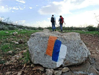
The Carmel forest along the Israel National Trail, with the trail's marker on the rock.
It was a brave-some may argue foolhardy-lot who recently braved the August heat of the Negev desert to walk a short segment of the Israel National Trail (INT) at around noontime.
But the nearly 100 young men in blue Israel Defense Forces t-shirts didn't appear to mind the blazing white heat. They were on the INT (Shvil Yisra'el in Hebrew, though to most Israelis it's just "the Shvil") to train.
"We get lots of practice on different altitudes," says Aaron Lion, 20. "The Shvil is a really good place to learn how to survive in lots of different conditions."
Now celebrating its 20th year, the INT takes a meandering 1,000-kilometer-plus (620-mile) route from Kibbutz Dan, among Israel's northernmost points, to the southern tip of Eilat's Gulf of Aqaba.
Since hiking enthusiast Avraham Tamir, fresh off an Appalachian Trail experience in America, dreamed of a national trail in Israel and made it a reality in 1995, hundreds of thousands have hiked its byways-from the green mountains of the north, to cities and towns, to the seemingly endless expanse of the Negev in the south.
Like other national trails, the INT makes it a point of showing off its natural beauty. But in a country where political pressures often divide the citizens, it has another goal: exposing Israelis and visitors alike to the wide variety of cultural and geophysical identities that fill the Jewish state. The peak months for the trail are February-May and October-December, avoiding Israel's rainy winters and sweltering summers.
But unlike other national trails, these 620 miles go beyond geography by also helping to bring Jewish history to life.
"Our family spends a lot of time learning Jewish history from books," says Michael Lindsey, a father of six from Jerusalem. "But when we hike the trail, I can say to the kids, 'This is the land of Benyamin,' or, 'This is where King David lived.' It brings the Torah to life for us."
"The trail is a walking lesson in both the history and geography of Israel," says Michal Maroz, a project manager for the Society for the Protection of Nature in Israel's (SPNI) tourism department, which maintains the trail, including the colorful painted streaks on trailside rocks that assure hikers they're still going in the right direction. "There are hikers who love the green of the north and those who prefer the dramatic vistas of the desert."
For Mimi Semuha, a grandmother and confirmed hiker who made aliyah from Upstate New York more than a half-century ago, the most profound experience was in Meron, the small town outside Safed best known as the burial spot of pioneering Kabbalist Rabbi Shimon Bar Yochai.
"There's a view from the top of the mountain where you are looking down into a wadi (valley) with a stream running through it," she says. "It's absolutely stunning."
There are folks-just out of the army or between jobs, or early (and fit) retirees-who opt to walk the trail in one fell swoop, a two-and-a-half or three-month undertaking. But most people will devote a few days or a week, taking months or even years to complete all 44 of the trail's legs.
"For a small country, Israel has so many climates and topographies," adds Maroz. "And many different cultures too."
One way the SPNI is celebrating the trail's 20th birthday is by joining Google Israel to map the INT for Google Street View, as part of the Google Treks project. This past spring, two teams of SPNI volunteers trekked the trail while schlepping 40-pound Google Street View cameras. Each camera contained 15 smaller cameras that snapped a panoramic image every five seconds. It took the teams 70 days to shoot the entire trail. Now being processed, the photos should be online by winter.
SPNI CEO Moshe ("Kosha") Pakman expects the exposure of the trail to inspire more people the world over to explore it. He is proud that National Geographic named the trail one of the 20 most beautiful hikes in the world.
"Displaying the INT through Google Street View will encourage tourists from Israel and abroad to experience the various cultures and landscapes of Israel, to fall in love with them, and take action to preserve them," he says.
Among the INT's assets are the "trail angels"-those who open their homes for hikers free of charge. Others, including some kibbutzim, charge very low prices for housing, and some throw in a shower and breakfast or the use their kitchen and Internet connection.
Other services include water stops along the way. One of providers, Yoash Limon, who also runs the Green Backpackers Hostel in the Negev town of Mitzpe Ramon, says that groups of hikers will band together to order water, thus reducing his delivery charges.
"There are hikers who come out in the summer down here," he says. "But they typically only walk in the early morning and late afternoon and yes, they drink plenty of water."
In fact, ordering water together is just one opportunity to get to know one's fellow INT hikers, says Limon. Shaya Pinson, an English teacher from Be'er Sheva, says the people he's met have been among the great joys of the many days he's spent on the INT portion from the Jerusalem Hills to the desert between Eilat and the Dead Sea.
"Like in many other Israeli situations which fall out of the norm, Israelis tend to feel and act in a remarkably bonded way upon meeting on the Trail," Pinson says. "It's kind of like meeting a distant family member by surprise in a distant land."
One organized way to meet people is a cross-cultural "dialogue" offered each winter for the last 10 years by HaMidrasha: Educational Center for Jewish Renewal in Israel. Designed as a memorial for Avi Ofner, an IDF soldier killed in a helicopter accident, the Israel Trail Encounters (Nifgashim B'Shvil Yisrael) are a series of "dialogues" from a number of perspectives along the journey.
"It's important to communicate and connect to feel our joint destiny," says HaMidrasha CEO Moti Zeira. "When you are sharing the Trail experience, something happens to open the heart to each other."
The INT is known as a safe, well-maintained trail. But the two greatest dangers (especially in the summer) are those ugly twins, dehydration and sun stroke.
"It's so important to come prepared-including [having] a good map," says veteran INT hiker Phyllis Shalem of Safed. "It's pretty surprising how quickly sun stroke and dehydration can happen, especially if you get lost."
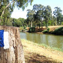
Dov Greenblat
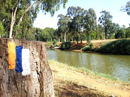
The Yarkon Park along the Israel National Trail, with the trail's marker on the tree stump.
For the well-prepared, however, the INT can be an unforgettable experience for Israeli residents and visitors alike.
"The trail tells the story of this country, its people and their legacy, its myriad vistas, and its flora and fauna," says SPNI's Pakman, who observes that the trail resembles a spinal cord, with its paths linking the entire country. "The Israeli essence is present along the trail: youth and students, soldiers, tourists from around the globe, families, and all types of nature lovers."
Just don't put it off, hiker dad Lindsey warns.
"People say, 'When I am between jobs or when I retire, I'll walk the trail,' but my best advice is don't wait until you have three months to spare," he says. "Take just a little piece now. After that, you will come back again."


Reader Comments(0)